Class 10 Geography Chapter 1 Map Study: Interpretation of Topographical Maps Important Questions
Here are some class 10 Map Study: Interpretation of Topographical Maps important questions and answers. These questions aim to aid students in practising and achieving high scores in their ICSE Class 10 Geography Examination 2024-25. Diverse question types will assist in clarifying doubts and effective exam preparation, enhancing problem-solving skills, and building confidence. ICSE class 10 geography important questions of Map Study: Interpretation of Topographical Maps will be helpful in scoring good marks and enhance the preparation for the exam.
Table of Contents
Introduction
Topographical maps serve as essential tools for understanding the Earth’s surface features, providing a detailed representation of the terrain through contour lines, symbols, and various annotations. As part of the class 10 Map Study curriculum, the interpretation of topographical maps holds significant importance in the field of geography. In this exploration of topographical maps, we will delve into key aspects and concepts that form the foundation of class 10 Map Study: Interpretation of Topographical Maps important questions and answers. As students progress through this module, they will encounter important questions and answers designed to reinforce their comprehension and analytical skills.
What is Map Study: Interpretation of Topographical Maps?
Map Study focuses on understanding and analysing various features represented on maps, such as relief, landforms, vegetation, water bodies, and human-made structures. Students learn to interpret contour lines, understand elevation, and identify key symbols and legends. They gain proficiency in deducing slope steepness, understanding land usage patterns, and comprehending the spatial distribution of geographical elements. Through map study, students develop crucial skills in spatial analysis, critical thinking, and map-reading abilities, essential for comprehending geographical landscapes and patterns.
Class 10 Map Study: Interpretation of Topographical Maps Important Questions and Answers
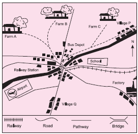
Q 1. What is the settlement pattern in the given image?
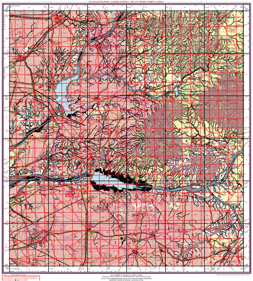
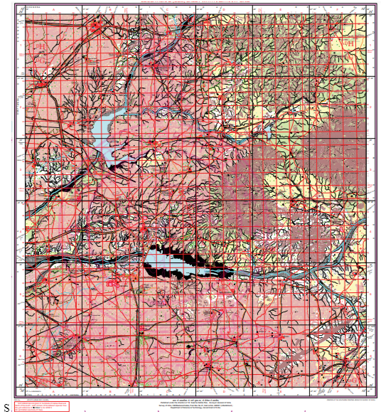
Q 3. Study the extract of the Survey of India Map Sheet No. 45D/7 (Eastings 29-35, Northings 76-85) and answer the following questions : Give the four figure grid reference of the perennial water source in the given toposheet.
Explanation:
Perennial water source is represented by blue colour and could be seen in grid square 3284 and 3384 .
Q 4. Study the extract of the Survey of India Map Sheet No. 45D/7 (Eastings 29-35, Northings 76-85) and answer the following questions :
(a) What do 8r in grid square 2978 and 18r in grid square 2976 refer to ? (b) What do the numbers 102, 103………107 written along the metalled road which is crossing the region from west to east, refer to ?
Explanation:
(a) They stand for relative height. The relative height of sand is 8 m in grid square 2978 and 18m in grid square 2976 respectively from the surrounding surface.
(b) These numbers are called kilometre stones or milestones. They are marked on a metalled road to make the people aware of how much they have travelled or how far they have come.
Q 5. Study the extract of the Survey of India Map Sheet No. 45D/7 (Eastings 29-35, Northings 76-85) and answer the following questions :
Which type of climate is experienced by the given region ? Comment on the type of region in the given toposheet.
Explanation:
The climate experienced by the given region is tropical monsoon. The region depicted here is a semiarid region; broken ground and presence of sand dunes support the statement.
Want to Master this Chapter?
Our Practice Tests, Mind Maps, and Key Questions will help!
If you are looking to further practice and enhance your understanding of the concepts discussed in the chapter, oswal.io provides a comprehensive set of icse class 10 important questions of Map Study: Interpretation of Topographical Maps for understanding the concept in a better way.
Ans: Map study refers to the examination and analysis of maps to understand geographical features, spatial relationships, and other relevant information. In the context of topographical maps, it involves the interpretation of terrain, elevation changes, and natural or man-made features.
Ans: Topographical maps are detailed representations of the Earth’s surface, showcasing elevation changes, landmarks, and physical features. They use contour lines, symbols, and colours to provide a comprehensive view of a specific area.
Ans: Interpretation of topographical maps is crucial for various purposes, such as planning outdoor activities, understanding landscapes, conducting environmental assessments, and aiding in navigation. It enhances spatial awareness and geographical knowledge.
Ans: Map study cultivates skills such as map reading, spatial analysis, and interpretation. It helps develop a deep understanding of geographical concepts, contour lines, scale, and symbols.
Ans: In ICSE Class 10 Geography, map study is an integral part of the curriculum. It focuses on interpreting topographic maps, and students learn to extract information, identify key features, and solve problems related to map reading.
Chapter Wise Important Questions for ICSE Board Class 10 Geography


 CBSE
CBSE Important Questions
 Class 10
 Maths
Maths Science
 Social Science
 English
 Biology
 Physics
 Chemistry
 Computer Applications
 History & Civics
 Geography
 Business Studies
 Economics
 Accountancy
 Political Science
 General Test